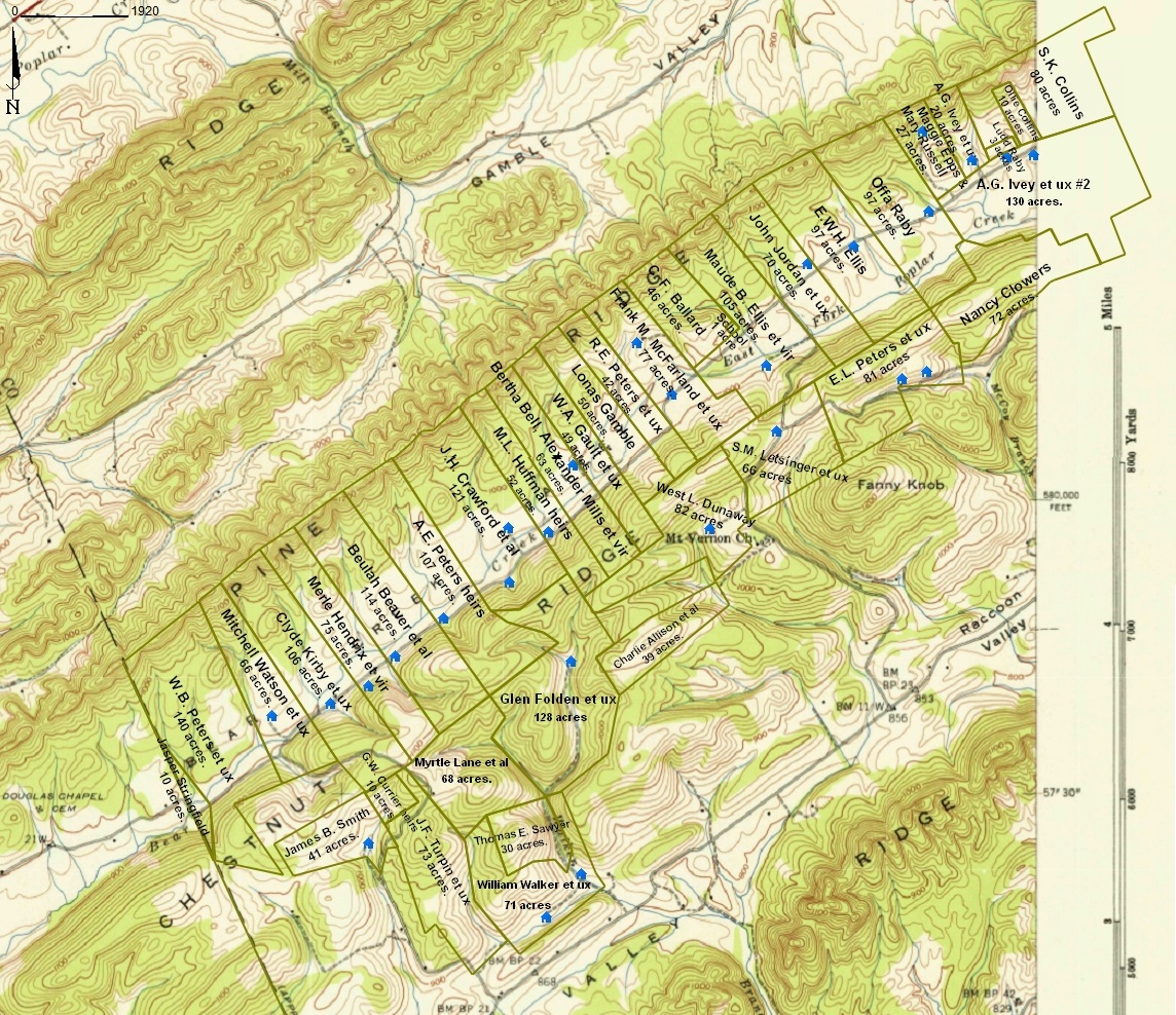
Bear Creek Valley area in Anderson County, Tennessee; a part of the Kingston Demolition Range:
a map of the area created using modern mapping software called Metes and Bounds by Sandy Knoll Software
|
The Kingston Demolition Range was the initial code name during WWII for the area of East Tennessee where the secret city of Oak Ridge came into existence and where the facilities were built to produce the enriched uranium for the Manhattan Project. The Manhattan Project was the overall project to develop the nuclear weapons that were used at the end of the war. Thousands of farm families were displaced within the Kingston Demolition Range in order to acquire the land needed by the Manhattan Project. The U.S. Army Corps of Engineers produced maps of the parcels of land that were taken for the project. This page represents an effort on my part to transform the original Kingston Demolition Range maps into maps of the same area on a modern topographical map. At the present time, I am using US Geological Survey topographical maps from 1941 for my mapping project. I'm using these maps rather than modern maps because it's easier to match up the U.S. Army's maps with topographical maps from the 1942 timeframe than it is with truly modern topographical maps. However, it should be easy at some point to replace the 1941 topographical maps on these pages with modern topographical maps while leaving the 1942 parcel boundaries unchanged. |
The northwest boundary for this area of Anderson County is Pine Ridge. Pine Ridge is a knife edge ridge which runs fairly straight from the southwest to the northeast. Each parcel of boundary along Pine Ridge extended all the way to the top of the ridge. Therefore, the northwest boundary of these parcels taken as a whole forms a fairly straight line. The location of the houses as indicated on the map is a guess based on the little black dots that were used in the USGS topo maps in 1941 to indicate structures. All the parcels contained houses, barns, etc. Therefore, the black dot from the USGS topo may have represented a barn or similar structure rather than a house, and for some of the parcels I couldn't find a black dot at all on the USGS topo map. The farms along Pine Ridge in this map were located in what what was then called then called Bear Creek Valley. The facilities in the Y-12 complex were built in Bear Creek Valley. So if I used a truly modern map as the background for my project, those parcels along the northwest edge of my map would all be overlaying Y-12. |
|
|
Bear Creek Valley area in Anderson County, Tennessee; a part of the Kingston Demolition Range:a map of the area created using modern mapping software called Metes and Bounds by Sandy Knoll Software
|
|
The next map below is a small sample of a much larger original map produced by the Army Corps of Engineers. I'm not sure what the official name of these maps is supposed to be. I have taken to calling them KDR maps as I work on them, because the file names of the maps from the National Archives all say KDR, and because they are all maps of the Kingston Demolition Range. |
This sample is from the same basic area of Bear Creek Valley as is the much more modern looking map above. Parcel B-141 belonged to W. B. Peters, parcel B-140 belonged to Mitchell Watson, parcel B-139 belonged to Clyde Kirby, etc. In any case, the goal of my project is to convert maps such as the one below into maps such as the one above. |
|
|
Bear Creek Valley area in Anderson County, Tennessee; a part of the Kingston Demolition Range:a small piece of an original 1942 U.S. Army Corps of Engineers map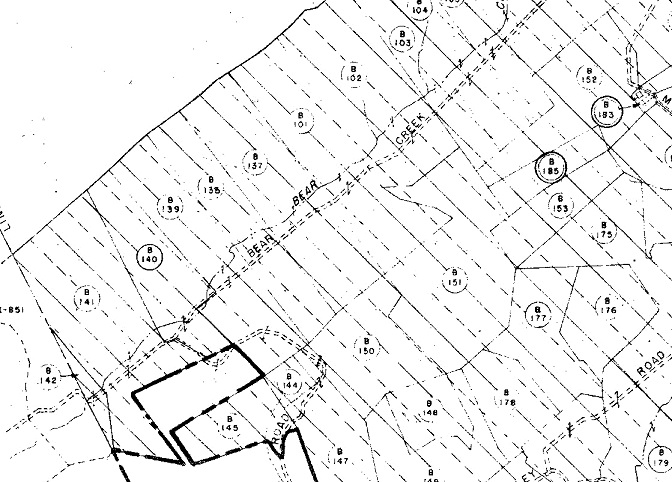
|
|
Finally, the map below is from my first feeble attempts to accomplish the project. I first tried Microsoft Paint, which is a very primitive graphics tool that comes free with Windows. It's actually more useful than most people give it credit for, but it really couldn't handle this project. Next I tried a program called GIMP. GIMP is much like a free version of Photoshop, and it is much more powerful than Microsoft Paint. In particular, GIMP supports layers, and this project really needs a graphics package that supports layers. But the maps I was able to produce with GIMP really didn't look much better than the maps I was able to produce with Microsoft Paint. The truth is that even though GIMP is a very powerful graphics package, it is not designed to be used for mapping applications. |
Finally, I found a software package called Metes and Bounds from Sandy Knoll Software, LLC. Metes and Bounds is specifically designed for mapping applications, and I'm very pleased with the results I have been able to produce so far using this package. It's the package I used to produce the very first map above. |
|
|
Bear Creek Valley area in Anderson County, Tennessee; a part of the Kingston Demolition Range:from my feeble attempts to accomplish my mapping project with Microsoft Paint or with GIMP
|
This page last edited on 11 Jul 2015.