William Cole was my second great grandfather. He has been my toughest genealogical brick wall. I am able to make an informed guess of his parents, but the guess is not 100% proven. This property purchased by a William Cole on 29 Jan 1869 has been instrumental in making that guess.
Originally, I thought this land was purchased by my William Cole. However, I now believe that this land was purchased by another man named William Cole who was the first cousin of my William Cole. I also believe that my William Cole lived on a portion of the land and paid taxes on it after the death of his cousin.
The 1870 census reports that my William Cole paid taxes on land worth $300. The going land value for tax purposes at the time appears to have been $10 per acre. That suggests that William was paying taxes on 30 acres. This deed was for 50 acres. Based on tax records, it appears that the William Cole who purchased the 50 acres died before the 1870 census. It also appears that my William Cole was living on a portion of the land at the time of the 1870 census, and that my William Cole was paying taxes on 30 of the 50 acres. Assuming that this theory is correct, I haven't identified who if anybody was paying taxes on the other 20 acres.
It is usually the case that it is very difficult to identify exactly where land is located just from its description in old deeds. Old deeds often describe land in terms of landmarks such as "large oak trees" that are no longer there, or in terms of adjacent parcels of land. Following descriptions of adjacent parcels can become very circular because if Smith's land is adjacent to Jones's land, then you check Jones's deed and discover that his land is adjacent to Smith's.
But in the case of William Cole's deed, there is enough information to locate the land. The land may be found where Middlebrook Pike and Plumb Creek (AKA Plum Creek) go through a gap in Beaver Ridge. At this point, the crest of Beaver Ridge was the boundary between Dist. 11 and Dist. 19. Because my William was known to be living in Dist. 19, references to the crest of the ridge and to the creek make it possible to locate the land fairly accurately.
One caution in interpreting this map is that there has been construction on Middlebrook Pike, and the intersection of Lovell Road with Middlebrook Pike hs been moved about fifty yards to the east to align with Ball Camp Pike. So the map no longer accurately reflects this aspect of the roads. The map is still accurate with respect to the parcel of land.
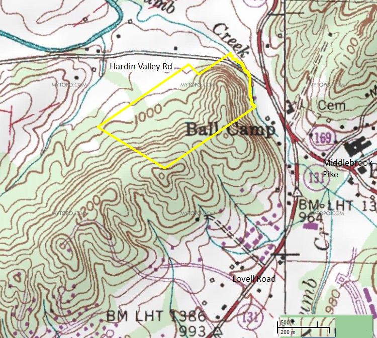
Here follows the relevant text from the deed: "on the waters of Plum creek and Beaver Ridge adjoining the lands of C. Morris, B.W. Smith, and others. Beginning on two Small Post Oaks Thence South fifty East Sixty Eight poles to a stake and marked pointer? on the top of Beaver Ridge thence north Fifty East ninety three poles to a Stake on the East bank of Plum creek thence down the East bank of Said creek as it meanders Fifty Six poles to a Stake in Murphy's line thence with Said line South Fifty Eight West twenty poles to a Stake thence North Fifty five West twelve poles to the Ball Camp line thence with Said line South fifty five west Eighty nine poles to the beginning containing fifty acres more or less..."
The beginning point of the description is the westernmost point of the land. The parcel is outlined in yellow, except for the eastern boundary which follows Plumb Creek. The key phrase that made it possible to locate the land was "... a stake and marked pointer? on the top of Beaver Ridge thence north Fifty East ninety three poles to a Stake on the East bank of Plum creek..." All that was necessary was to place a line that followed the crest of the ridge and ended on the east bank of the Creek, to adjust the length of the line to proper scale, and everything else followed. Fortunately, "north Fifty East ninety three poles" did create a line that properly followed the contour of the crest of the ridge.
I have worked out the simple geometry of the description of the land and I come up with about 52.8 acres, which is very close to the "fifty acres more or less" that is listed in the deed. My calculations include a little uncertainty because the creek does not run straight, and the creek is the east boundary of the property.