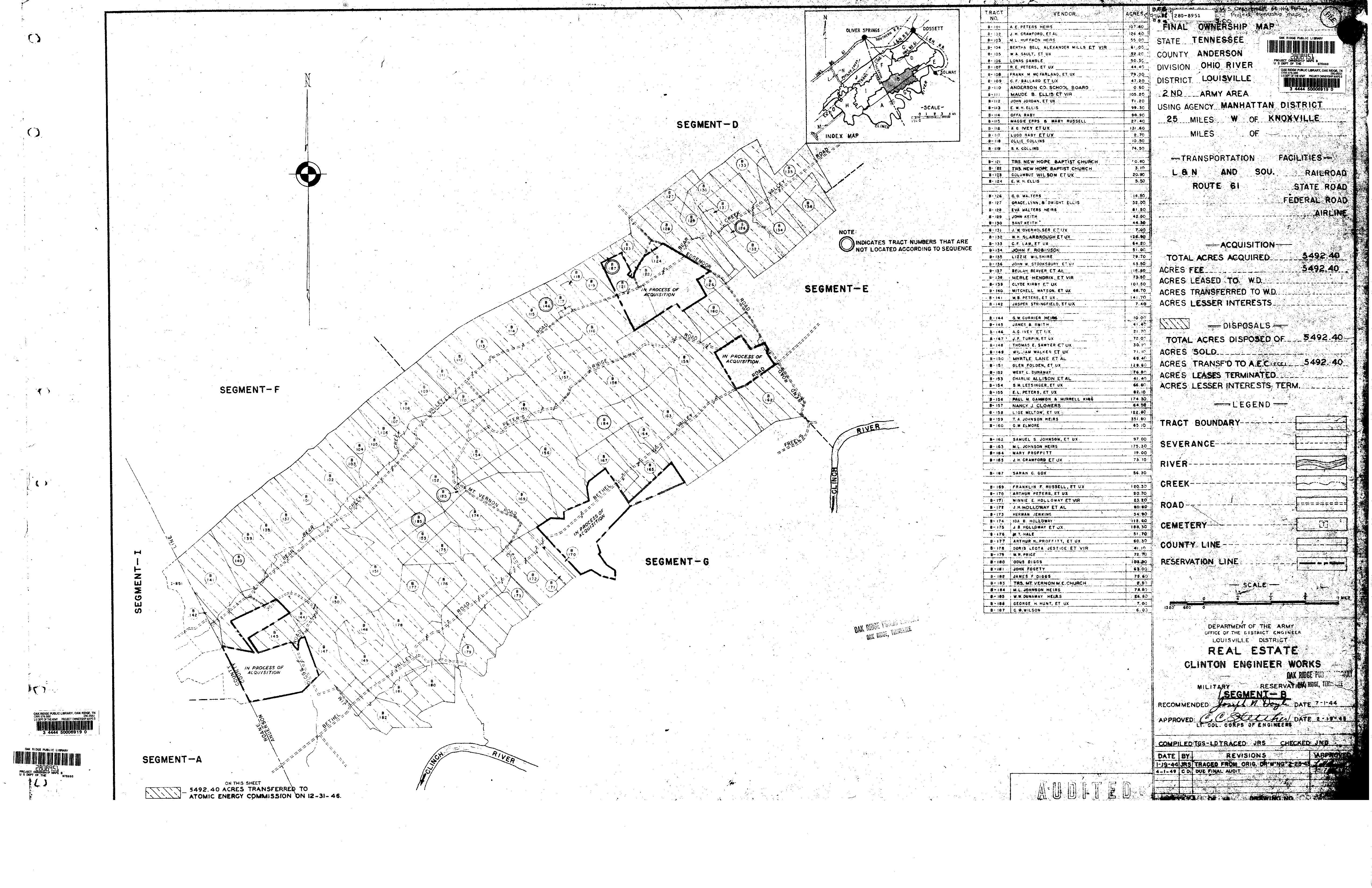
- I have many ancestral lines from Anderson County, Tennessee. In 1942 the U.S. government displaced thousands of residents of Anderson County to build the secret city of Oak Ridge as a part of the Manhattan Project to develop the atomic bomb. In turn, the U.S. Army Corps of Engineers produced maps of Anderson County in 1942 which display most of the properties that were taken.
- The 1942 Corps of Engineers maps are a wonderful resource as they stand. Nevertheless, I think the presentation of the maps can be improved. Therefore, I have been working on a project to display those maps on modern maps including the use of Google Maps.
- My primary tool for this project is a piece of software called Metes and Bounds. I have been entering the Corps of Engineers maps into the Metes and Bounds software. In turn, the Metes and Bounds software can produce KML files that can be fed into Google Maps. In addition to producing KML files, Metes and Bounds software can produce JPG files. And in addition to Google Maps, KML files can be fed into a Google Maps App called GMAP4.
- Each of these modes of presentation - Google Maps, a JPG file, and GMAP4 - have their advantages and disadvantages. So I'm including all three modes of presentation on this page.
This is a work in progress, and I am constantly adding new properties to the maps. With respect to the properties that are on the maps so far, I'm primarily interested in those associated with the Peters family. In addition, the property on the map owned by J. W. Pyatt was originally owned by my fourth great grandfather William Cross.
- E. L. Peters was my maternal grandfather Ernest Lester (Lester) Peters Sr.
- S. M. Letsinger was Samuel Mabry (Sam) Letsinger who was Lester Peters' brother-in-law, having married Lester's sister Elza Cordelia (Elzie) Peters. Papaw Peters and Uncle Sam purchased their respective farms the same day, and both farms were purchased from Uncle Sam's parents William Johnson Letsinger and Elizabeth Frances (Fannie) Meade. The purchases were essentially a partition of the old William Letsinger farm.
- W. B. Peters was Lester's brother William Birchell (Birchell) Peters.
- A. E. Peters was Lester's father Alva Edward (Alvy) Peters. Both Alvy and his wife Sallie Jane Cole died in 1942 prior to the government taking of the land in Anderson County. Therefore, the money the government paid for the A. E. Peters property went to the heirs.
- R. E. Peters was Lester's brother Robert Earl (Bob) Peters.
- Arthur Peters was Lester's brother Samuel Arthur (Arthur) Peters. Uncle Arthur married Edna Pearl Holloway. The adjacent property labeled "Minnie Holloway et. vir." on the Army Corps of Engineers maps was owned by Aunt Edna's parents Joseph Elmer (Elmer) Holloway and Minnie Elizabeth Moneymaker. Most of the properties were listed by the Army in the husband's name plus "et. ux." (and wife). But a few of the properties were listed by the Army in the wife's name plus "et. vir." (and husband), and this was one such property.
Section B17, Army Corp of Engineers Maps, Anderson County, Tennessee, 1942. This is primarily the Bear Creek Valley area plus a part of the Scarbrough community.
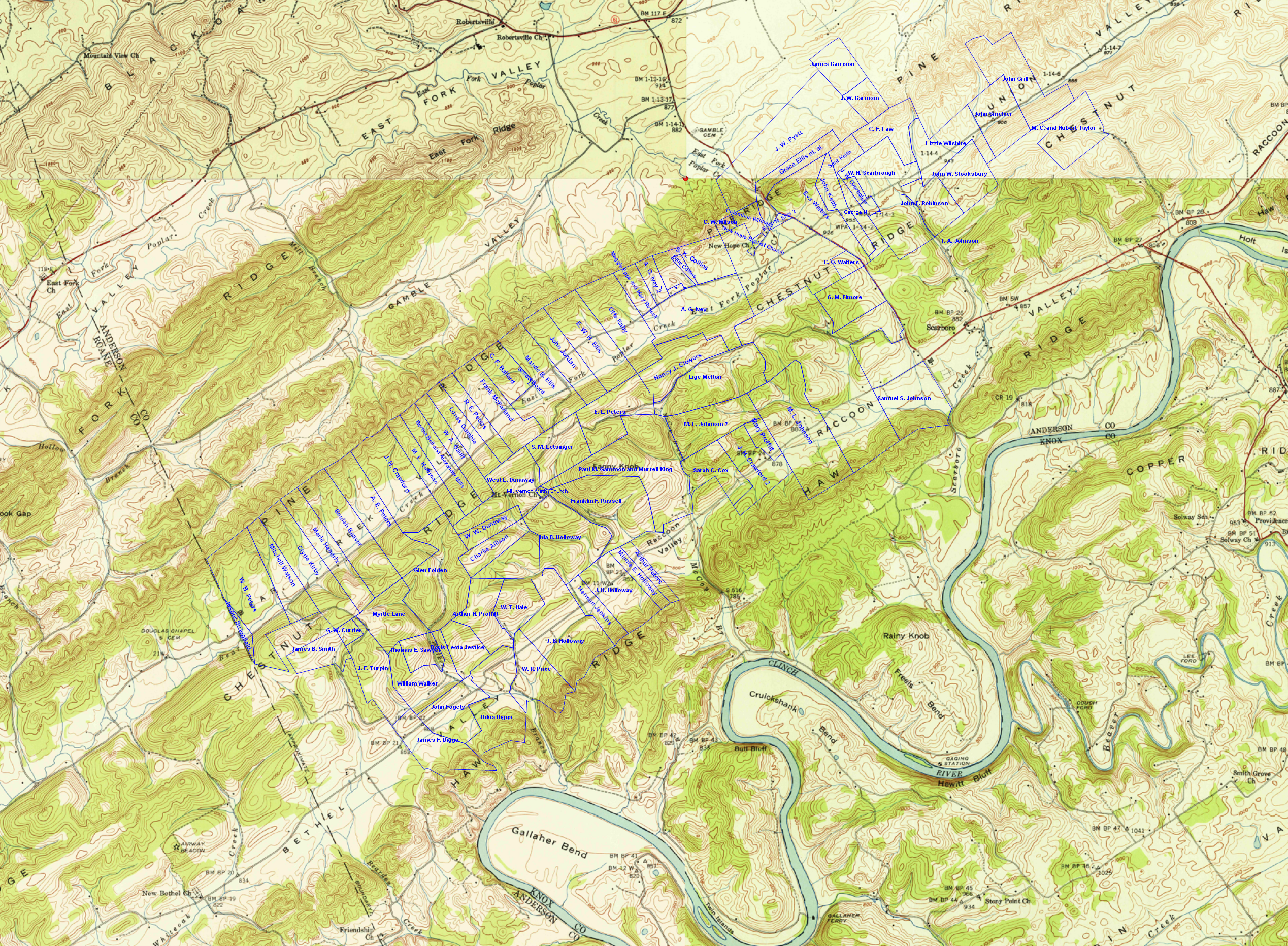
A map of the properties from 1942 Army Corps of Engineers maps, transposed onto U.S.G.S quadrangle maps from the same timeframe.
A Google Maps version of the same data. The Google Maps version of the data was created by exporting a KML file from the Metes and Bounds software and importing the KML file into Google Maps. I modified the KML file to place pins on each parcel of land, and the pins also created an index along the left hand side of the map. I have not found a way to create labels in Google Maps from a KML file.
A GMAP4 version of the same data. GMAP4 is a Google Maps app which
supports adding labels directly from a KML file. The same KML
file is used both for the Google Maps version of the map and
the GMAP4 version of the map.
Open this map full screen.